Why the Langtang Valley Trek map is Essential
Navigating the rugged terrain of the Himalayas is an exhilarating experience, but it requires more than just a sense of adventure. Whether you are a first-time trekker or a seasoned hiker, the Langtang Valley Trek map is a vital tool that transforms a simple walk into a well-managed expedition. It serves as a safety net, a planning guide, and a cultural storyteller, ensuring you don't just reach your destination but truly understand the land you are walking through. While the trails are generally well organized, having a map provides a deeper sense of independence and connection to the breathtaking landscapes of the Langtang region.
Navigation and Safety in the Wild
The primary reason to keep a map handy is, of course, your safety. The trail leads you deep into Langtang National Park, where the path winds through dense rhododendron and bamboo forests that can sometimes be disorienting. A reliable map helps you stay on the right track, preventing wrong turns and ensuring you reach your nightly teahouse before sundown. More importantly, in the event of an emergency, such as sudden bad weather or injury, the map highlights the nearest villages, water sources, and possible exit routes, which are critical for making quick, informed decisions in the wild.
Tracking Altitudes and Distances
Managing your physical exertion is key to enjoying the Himalayas, and a map is your best tool for logistical planning. The Langtang trek involves a steady and gradual ascent, taking you from the trailhead at Syabrubesi (1,460m) up to the spiritual heart of the valley, Kyanjin Gompa, at 3,870m. By using a map to track your daily walking distances (typically 5 to 15 kilometers) and significant elevation changes, you can pace yourself effectively. This foresight is essential for acclimatization, as the map clearly shows elevation profiles that help you plan rest stops and ensure your body adjusts naturally to the thinning air, significantly reducing the risk of altitude sickness.
Identifying Cultural Landmarks and Viewpoints
A trek map does more than just show the way; it enriches your journey by acting as a guide to the region's rich Tamang culture and geographic wonders. As you hike, the map helps you identify the majestic snow-capped peaks towering above you, such as Langtang Lirung (7,246m), Ganesh Himal, and Yala Peak. It also highlights significant cultural sites, such as the ancient Kyanjin Gompa monastery and traditional settlements, that you might otherwise walk past without fully appreciating. Furthermore, the map ensures you don't miss out on spectacular side trips to iconic viewpoints like Kyanjin Ri (4,400m) or Tserko Ri (approximately 5,030m). Here, you can witness some of the most stunning sunrises in the world.
Route Overview: From Kathmandu to Kyanjin Gompa
The journey from the urban bustle of Kathmandu to the high-alpine serenity of Kyanjin Gompa is an epic transition through Nepal’s diverse geography. This 10-day route is a masterclass in gradual ascent, taking you from the valley floor deep into the heart of the Himalayas. It is not just a trail; it is a "nature trek and a spiritual journey" that leads you through the "Valley of Glaciers." By following the Langtang Valley Trek map, you can trace your progress from the lower subtropical forests to the towering peaks of the Langtang range.
Starting Point: The Drive to Syabrubesi
Your Himalayan adventure officially begins with a scenic drive from Kathmandu (1,300 m–1,310 m) to Syabrubesi (1,460 m–2,000 m), the recognized gateway to the Langtang region. This 122-kilometer journey typically takes between 7 and 10 hours on a public bus or private vehicle. As you leave the city behind, the road winds through lush hills and rural landscapes, passing through local towns such as Dhunche, Trishuli, and Kakani. This drive is your first introduction to rural Nepal, offering glimpses of terraced fields and distant peaks like Ganesh Himal before you even set foot on the trail.
Walking Through Langtang National Park
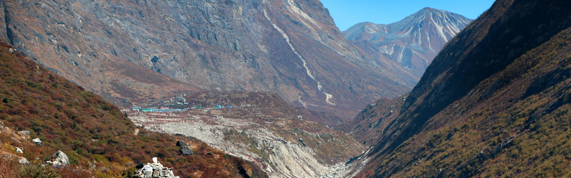
Once you reach Syabrubesi, the real magic begins as you enter Langtang National Park. The trail follows the roaring Langtang River (Langtang Khola), leading you through a vibrant world of rhododendron, bamboo, pine, and oak forests. This section of the trail is alive with nature; it "buzzes with the songs of unseen birds and the rustling leaves," and if you keep a sharp eye out, you may spot monkeys or rare red pandas.
The path is dotted with welcoming milestones and traditional Tamang villages:
- Lama Hotel (2,470m): After about 5.5 hours of walking from Syabrubesi, you reach this forest-bound settlement, passing through areas like Bamboo along the way.
- Langtang Village (3,430m): A 6 to 7-hour gradual ascent through pine forests leads you to this picturesque settlement, which was beautifully rebuilt after the 2015 earthquake. Here, you can witness a unique blend of Tibetan and Nepalese cultures.
- Kyanjin Gompa (3,860 m–3,870 m): The final leg is a shorter, scenic walk into the spiritual heart of the valley. Surrounded by snow-white peaks like Langtang Lirung (7,246m), this sacred area features an ancient monastery, yak pastures, and a famous local cheese factory where you can try fresh yak cheese.
The route provides panoramic views of glaciers and peaks, making the steady climb a rewarding experience for trekkers of all levels.
Detailed Day Itinerary Highlights
A well-structured 8-day itinerary is the gold standard for exploring the "Valley of Glaciers," balancing physical exertion with cultural immersion. Using a detailed Langtang Valley Trek map allows you to navigate the diverse terrains of Langtang National Park, from lush subtropical forests to high-alpine viewpoints. While the journey officially includes arrival and departure days in Kathmandu, the heart of the adventure lies in the following trekking route.
Day 1: The Scenic Drive from Kathmandu to Syabrubesi
Your Himalayan expedition begins with a 7 to 8-hour drive from the capital city to Syabrubesi, located at an altitude of approximately 1,460 meters. This 122-kilometer journey winds through scenic hills and rural landscapes, passing through local towns like Trishuli, Kakani, and Dhunche. As you leave the city behind, you will catch your first glimpses of the Ganesh Himal range towering in the distance. Syabrubesi serves as the official entrance to the national park and the starting point for your trek.
Day 2: Syabrubesi to Rimche
On the first day of walking, you will trek for 4 to 5 hours, covering a distance of 8 kilometers to reach Rimche [User Query]. The trail follows the roaring Langtang River, leading you through dense forests of rhododendron, oak, and bamboo. This section is a haven for nature lovers, often "buzzing with the songs of unseen birds" and offering chances to spot local wildlife like monkeys or rare red pandas. The path involves a steady climb through the forest, providing a cool and shaded environment as you begin your ascent.
Day 3: Deep into the Valley from Rimche to Langtang Village
Continuing further into the heart of the region, you will trek 4 to 5 hours over a 6-kilometer stretch to arrive at Langtang Village (3,430 meters). As the dense forests begin to thin, the valley opens up to reveal stunning views of the Langtang range. Langtang Village is a picturesque settlement that uniquely blends Tibetan and Nepalese cultures. It is a place of great resilience, having been beautifully rebuilt with stone houses following the 2015 earthquake.
Day 4: Trek to Kyanjin Gompa
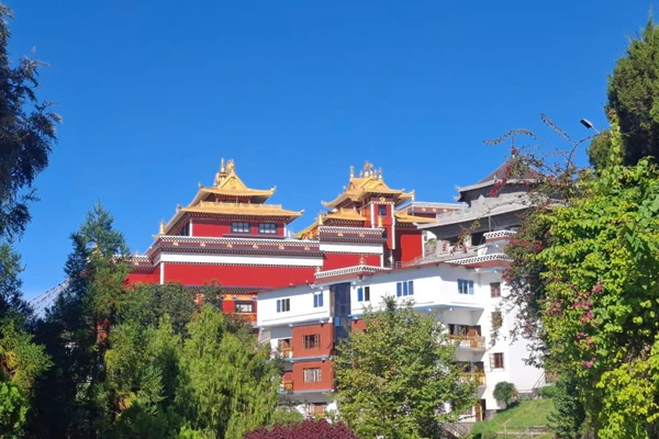
This shorter 3-hour walk covers 4 kilometers and brings you to Kyanjin Gompa (3,870 meters), the spiritual center of the trek. Along the way, you will pass sacred prayer flags, ancient mani walls, and wide yak pastures. Once you arrive, you can visit the famous local cheese factory to sample fresh yak cheese, a "must-do" for every traveler. You will also have the opportunity to visit the first monastery in the area, a sacred site surrounded by the massive glaciers of Langtang Lirung.
Day 5: Tserko Ri Challenge
Today is dedicated to the trek's most challenging and rewarding objective. We will summit Tserko Ri. This 7- to 8-hour round trip covers 10 kilometers and serves as a peak experience for adventurous trekkers. From the summit, you are rewarded with a 360-degree panoramic vista of the entire Langtang range, including Yala Peak and Langtang II. The breathtaking sunrise views from this height make it a true "photographer’s paradise."
Day 6: Kyanjin Ri to Mundu
The morning begins with a sunrise hike to Kyanjin Ri (4,400 meters), a popular viewpoint that offers spectacular perspectives of the surrounding snow-capped peaks. After soaking in the views, you will begin your descent, walking 5 to 6 hours over 6 to 7 kilometers to reach the village of Mundu. Retracing your steps allows you to enjoy the scenery from a different angle while your body benefits from the easier downhill walking.
Day 7: Retracing from Mundu to Bamboo
Your journey back toward civilization continues with a 5 to 6-hour trek from Mundu to Bamboo. The trail takes you back through the lush greenery of the lower valley, following the Langtang Khola once again. This segment is perfect for reflecting on your high-altitude achievements while enjoying the peaceful vibe of the riverside trail. Bamboo is a quiet forest settlement where you can rest before the final leg of your trek.
Day 8: Final Descent to the Capital
The trekking portion of your adventure concludes with a 3 to 4-hour walk from Bamboo back to Syabrubesi. After reaching the trailhead and celebrating your successful journey, you will board a vehicle for the 7 to 8-hour drive back to Kathmandu. Arriving back in the city, you can enjoy a farewell dinner to celebrate your completion of one of Nepal's most beautiful treks. You will depart with unforgettable Himalayan memories and a deep appreciation for the Tamang culture.
Altitude and Elevation Profile
Understanding the "ups and downs" of the Himalayas is perhaps the most important part of your preparation. The Langtang Valley Trek map serves as a visual guide to these changes, showing a route that is widely respected for its gradual and manageable elevation gains. Unlike some treks that throw you into high altitudes immediately, Langtang allows your body to find its rhythm, making it an ideal choice for those new to mountains. By tracking your elevation daily, you can ensure a safe, enjoyable journey into the heart of the "Valley of Glaciers."
Managing Gradual Ascent to 3,870m
The journey begins at a relatively low altitude in Kathmandu (1,310m) before you drive to the trailhead at Syabrubesi, situated at approximately 1,460m to 2,000m. From here, the trek follows a steady upward trajectory designed for natural acclimatization. Your first major climb takes you to Lama Hotel (2,470m), followed by a push to the resilient Langtang Village at 3,430m.
The primary destination for us is Kyanjin Gompa. It is the spiritual heart of the valley, sitting at 3,860m to 3,870m. Throughout this ascent, you will typically walk between 5 and 7 hours per day, covering distances of 8 to 15 kilometers. This "slow and steady" pace is the secret to a successful trek; it gives your body the necessary time to adjust to the thinning air, significantly reducing the risk of altitude sickness and ensuring you have enough energy to enjoy the stunning scenery.
Reaching the Highest Viewpoint: Tserko Ri (5,030m)
For those looking to push their limits, the trek offers an optional but exhilarating challenge: the climb to Tserko Ri. Standing at a breathtaking height, this is the highest point most trekkers will reach in the Langtang region. This summit is often tackled as a day hike from Kyanjin Gompa, involving a demanding 6- to 7-hour round trip.
Reaching the top of Tserko Ri is a peak experience in every sense of the word. From this vantage point, you are rewarded with a 360-degree panoramic vista of the Langtang range, including the massive Langtang Lirung (7,246m), Langtang II, and Yala Peak. If you prefer a slightly less strenuous option, the map also highlights Kyanjin Ri at 4,400m, which still offers spectacular sunrise views and helps with altitude adjustment. Whether you choose the ultimate challenge of Tserko Ri or the scenic heights of Kyanjin Ri, these viewpoints represent the physical and emotional pinnacle of your Himalayan adventure.
Key Landmarks & Cultural Encounters
The Langtang Valley Trek is more than just a physical challenge; it is a deep dive into the soul of the Himalayas. As you follow your Langtang Valley Trek map, you are not just navigating trails but entering a world where ancient traditions meet a breathtaking natural sanctuary. This segment of the journey is filled with stunning mountain scenery, diverse wildlife, and profound cultural encounters that stay with you long after you leave.
Traditional Tamang Villages and Tibetan Influence
As you trek through the valley, you will explore traditional settlements like Lama Hotel, Langtang Village, and Kyanjin Gompa. These villages are primarily inhabited by the Tamang people, who are known for being incredibly friendly and welcoming to travelers. Langtang Village itself is a picturesque settlement that uniquely blends Tibetan and Nepalese cultures, offering a glimpse into a way of life that has thrived here for millennia. A visit here is particularly poignant, as the village consists of stone houses that were beautifully rebuilt after the 2015 earthquake. Mingle with the locals to learn about their old customs, traditions, and legendary hospitality.
Langtang National Park Wildlife
The trail is a nature lover's dream, taking you deep into the heart of Langtang National Park. This protected area is a sanctuary for rare and elusive wildlife, including the red panda and the Himalayan thar. As you walk through lush forests of rhododendron, bamboo, oak, and pine, you will find the air "buzzing with the songs of unseen birds and the rustling leaves." Beyond the animals, the landscape is decorated with waterfalls, crystal-clear streams, and wide yak pastures. You can watch these sturdy animals graze against a backdrop of snow-capped peaks.
Ancient Monasteries and Sacred Sites
For many, the spiritual heart of the journey is reached at Kyanjin Gompa, a sacred monastery surrounded by majestic mountains and glaciers. This area serves as a peaceful spiritual sanctuary where you can join in local rituals and absorb the "peaceful vibe" of ancient Buddhist traditions. Your Langtang Valley Trek map will also guide you to sacred sites such as ancient mani walls and prayer flags that flutter in the mountain breeze. While exploring the landmarks, do not miss the famous local cheese factory in Kyanjin Gompa. Trying the freshly made yak cheese is a "must-do" for every trekker and offers a delicious taste of the region’s local culture.
Trek Logistics & Planning
Planning a journey into the Himalayas requires more than just physical fitness; it demands a solid understanding of the logistics that make the adventure possible. From timing your visit to perfectly capture the mountain vistas to ensuring you have the legal right to walk through protected lands, these details are the backbone of a successful trip. By organizing your permits and understanding the local accommodation style, you can focus entirely on the "unforgettable Himalayan memories" that await you on the trail.
Best Seasons: Spring and Autumn
Choosing the right time to visit the Langtang region is crucial for both safety and visibility. According to the sources, the best seasons for the Langtang Valley Trek are Spring (March to May) and Autumn (September to November). During these windows, you are treated to clear skies, mild temperatures, and minimal rain. This creates safer hiking conditions and offers the most stunning, unobstructed views of the surrounding peaks and valleys. Spring is particularly beautiful as the rhododendron and oak forests are in full bloom, while Autumn provides the crispest air for photography. While trekking outside these months is possible, these two periods are considered the "gold standard" for a comfortable and visually rewarding experience.
Required Permits: TIMS and National Park Entry
Navigating the legalities of trekking in Nepal is straightforward but essential for environmental protection and your own safety. For the Langtang Valley Trek, you are required to obtain a Langtang National Park entry permit. These permits can be conveniently secured in Kathmandu or directly at the trailhead for a small fee. These documents serve a dual purpose: they help local authorities track trekkers for safety and emergency management, and the fees contribute directly to the conservation efforts of the park. Carrying these permits and your Langtang Valley Trek map ensures you are prepared for checkpoints and have a smooth, legally compliant journey.
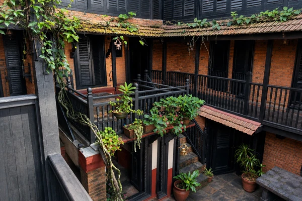
Accommodation: Tea Houses and Local Hospitality
One of the most charming aspects of trekking in this region is the unique style of lodging. You won't find luxury hotels deep in the valley; instead, you will stay in simple teahouses, guesthouses, and lodges run by local families. These accommodations offer basic beds and warm meals, providing a "warm, friendly atmosphere" where you can rest after a long day of walking. While the facilities are modest, some lodges offer hot water for showers at an extra cost.
The cost of staying in these tea houses is remarkably affordable, typically ranging between $5 and $20 per night. This style of accommodation allows you to immerse yourself in the Tamang and Tibetan-influenced culture, as you’ll often find yourself sharing stories with locals and other travelers in common dining areas. Additionally, don’t miss the chance to try fresh yak cheese at the famous factory in Kyanjin Gompa, which is a staple of the local culinary experience. Planning your stay in these lodges is an essential part of the trek’s "cozy and comfortable" logistical appeal.
Why the Langtang Route is Unique
The Langtang Valley Trek stands out as a "nature trek and a spiritual journey" that offers a distinct experience compared to other regions in Nepal. Often referred to as the "Valley of Glaciers," it provides an intimate look at the Himalayas that balances raw natural beauty with a profound cultural narrative. Its uniqueness lies in its accessibility, its resilience, and the fact that it remains less crowded than the famous Everest or Annapurna circuits.
Stress-Free Accessibility
One of the most practical reasons the Langtang route is unique is that it requires no domestic flights to reach the trailhead. While other famous treks often require flying into high-altitude, weather-dependent airports like Lukla, the journey to Langtang begins with a scenic mountain drive from Kathmandu to Syabrubesi.
This road-based approach, which covers approximately 122 kilometers and takes between 7 to 10 hours. It significantly reduces travel risk, costs, and the common anxiety of flight cancellations or delays. For travelers, this means a more reliable schedule and a budget-friendly start to their adventure. The drive itself is a cultural introduction, winding through rural villages like Dhunche, Trishuli, and Kakani. These small towns pass through the views of terraced fields and distant ranges like Ganesh Himal before you even start walking.
Proximity to Kathmandu: The Closest Himalayan Wilderness
Langtang is officially recognized as the closest Himalayan wilderness to the Kathmandu Valley. Located directly north of the capital near the Tibet border, its geographic location allows you to transition from urban life to high-alpine serenity in just one day.
This proximity is a game-changer for those with limited time; the short travel distance means more time spent on the actual trail and less time in transit. Despite being so close to the city, the region maintains a "peaceful vibe," offering serene valleys and less crowded paths than its more famous counterparts. It provides a rare opportunity to reach a maximum altitude of 3,870 meters (at Kyanjin Gompa) or even a 5,030-meter viewpoint (Tserko Ri) without a week-long trek just to reach the base of the mountains.
A Cultural and Resilient Heart: The Tamang Heritage
The Langtang route is uniquely defined by its people and their history. The valley is home to the Tamang people, who are known for their "warm hospitality, unique traditions, and Buddhist heritage". Trekkers have the chance to mingle with locals and learn about ancient customs that have remained unchanged for millennia.
A core part of this trek’s identity is its story of resilience. Langtang Village (3,430m) was completely destroyed during the 2015 earthquake but has since been beautifully rebuilt with traditional stone houses, serving as a poignant testament to the strength of the community. The cultural journey culminates at Kyanjin Gompa, a "spiritual sanctuary" featuring an ancient monastery surrounded by glaciers. Here, the unique blend of Tibetan and Nepalese cultures is palpable, and no visit is complete without trying the famous local yak cheese, which is freshly made in the village and celebrated across the entire region.
Diverse Landscapes and Rare Wildlife Sanctuary
Unlike treks that focus solely on high peaks, the Langtang route offers a rich biodiversity within Langtang National Park. The trail is a sensory experience, "buzzing with the songs of unseen birds and the rustling leaves" as you pass through lush rhododendron, bamboo, oak, and pine forests.
This region is a sanctuary for rare wildlife, including the elusive red panda and the Himalayan thar. As you ascend, the landscape transforms from dense greenery into wide alpine meadows, waterfalls, and crystal-clear streams. The views will open up to panoramic snow-white peaks such as Langtang Lirung (7,246m), Langtang II, and Yala Peak. The combination of these dramatic glaciers and high-altitude peaks within such a short distance from the trailhead makes Langtang one of the most geographically diverse and scenic short treks in all of Nepal.
Frequently Asked Questions (FAQ)
Is the trek suitable for families?
Yes, this route is considered beginner-friendly and suitable for families with older children because it follows a straightforward main trail with comfortable daily walking hours and regular tea houses for rest.
How difficult is the daily walking distance?
The daily distance is easy to manage, with trekkers typically covering 5 to 15 kilometers over 5 to 7 hours of walking. The overall difficulty is rated as moderate, making it accessible for those with average fitness levels.
Where can I download a detailed map?
You can download up-to-date PDFs and detailed trek maps from our website.
How do Langtang, Annapurna, and Everest trekking experiences differ?
Langtang offers a less crowded and more serene experience compared to the busy trails of Everest or Annapurna. Additionally, unlike Everest, Langtang is accessible by road, meaning no domestic flights are required to reach the trailhead.
How do maps help with tracking altitude gain?
A detailed map clearly shows elevation changes between each trekking segment, allowing you to track your ascent and plan essential rest stops for natural acclimatization.
Can I use a map to find hidden viewpoints?
Yes, maps are essential for highlighting scenic viewpoints and landmarks, such as glaciers, that you might otherwise miss while navigating the forest trails.
What wildlife might I spot while trekking through Langtang National Park?
The park is a sanctuary for diverse species; you may spot rare red pandas, Himalayan thar, monkeys, and many types of birds.
How do Kyanjin Ri and Tserko Ri views compare for sunrise?
Tserko Ri (5,030m) is the highest point of the trek and offers the most breathtaking 360-degree sunrise views. Kyanjin Ri (4,400m) is a popular and slightly more accessible viewpoint that still provides stunning panoramas of the Langtang range.
What does the famous yak cheese at Kyanjin Gompa taste like?
The sources do not provide specific flavor descriptors like "salty" or "sharp," but they emphasize that the cheese is freshly made at a local factory and is famous across the entire Langtang region.
Conclusion
When preparing for a journey into the Himalayas, many travelers have similar concerns regarding safety, logistics, and the physical demands of the trail. The Langtang Valley Trek is widely considered an excellent choice for first-time adventurers and families. It is rated with a moderate difficulty level, featuring scenic trails and gradual elevation gains. Families with older children will find the route particularly suitable because it follows a straightforward main trail with minimal confusing junctions and features regular tea houses for rest along the way. This ease of access and manageable terrain make it a premier option for those who want to experience the majesty of Nepal’s mountains without the extreme physical toll associated with more rugged regions.
Regarding the daily physical commitment, the trek covers a total distance of approximately 70 to 80 kilometers for the round trip, which is typically completed over a period of 7 to 10 days. Most trekking days involve manageable walking durations of 5 to 7 hours, with trekkers covering between 8 and 15 kilometers per day. While the early stages of the journey consist of gentle uphill walks through lush forests, the mid-trek segments involve steeper climbs as you approach the 3,800-meter mark.


