Why a Trekking Map is Your Most Essential Gear
In an era of GPS and smartphones, you might wonder why a physical, folded piece of paper remains the most vital item in a trekker's pack. The truth is, an Everest Base Camp (EBC) map is far more than a tool for orientation. It is a roadmap of lived experience that captures every ridge, glacier, and Sherpa settlement you will encounter along the way. It serves as a "silent advisor," helping you navigate the delicate balance between the physical challenge of the trail and the breathtaking beauty of the landscape.
A Shield for Your Safety
The Himalayas are as unpredictable as they are beautiful. For many, especially solo travelers, a map is a primary safety net that prevents them from straying off the path or accidentally entering restricted areas. While the main trail is well-trodden, the high-altitude environment can become disorienting in mist or snow. Having a map ensures your safety by enhancing your insight into the trail, allowing you to walk with the confidence that you are exactly where you need to be.
Perspective and Peace of Mind
Trekking at 5,000 meters changes your perception of time and distance. A map puts the vastness of the Khumbu into perspective, helping you visualize the distance to your next destination. It allows you to schedule your trek according to your own pace and preference, offering a reliable estimation of when you will arrive at your teahouse for the night. One of the most precious pieces of Khumbu guidance is to ignore standard hour estimates for kilometers; instead, use your map to listen to your body and reach your goal intentionally.
Unlocking Secret Attractions
Beyond the red line of the main trail lies a world of "secret attractions." A detailed map encourages a sense of adventure, giving you the information needed to take short detours to explore surrounding monasteries, hidden viewpoints, or local landmarks you might otherwise miss. By tracing the contour lines, you aren't just looking at geography; you are reading a dynamic story of height and camaraderie, connecting with the spirit of the trek before you even take your first step.
Reliability When Technology Fails
While digital tools like Google Maps are helpful secondary resources, the extreme cold of the Himalayas is notorious for draining phone batteries rapidly. A physical map doesn't require a charge or a satellite signal. It empowers you to be prepared for the "miracles and difficulties" of the trail, ensuring that even in the most remote corners of the Sagarmatha National Park, you have a reliable guide to lead you home.
Stage-by-Stage Route Breakdown (Distances & Durations)
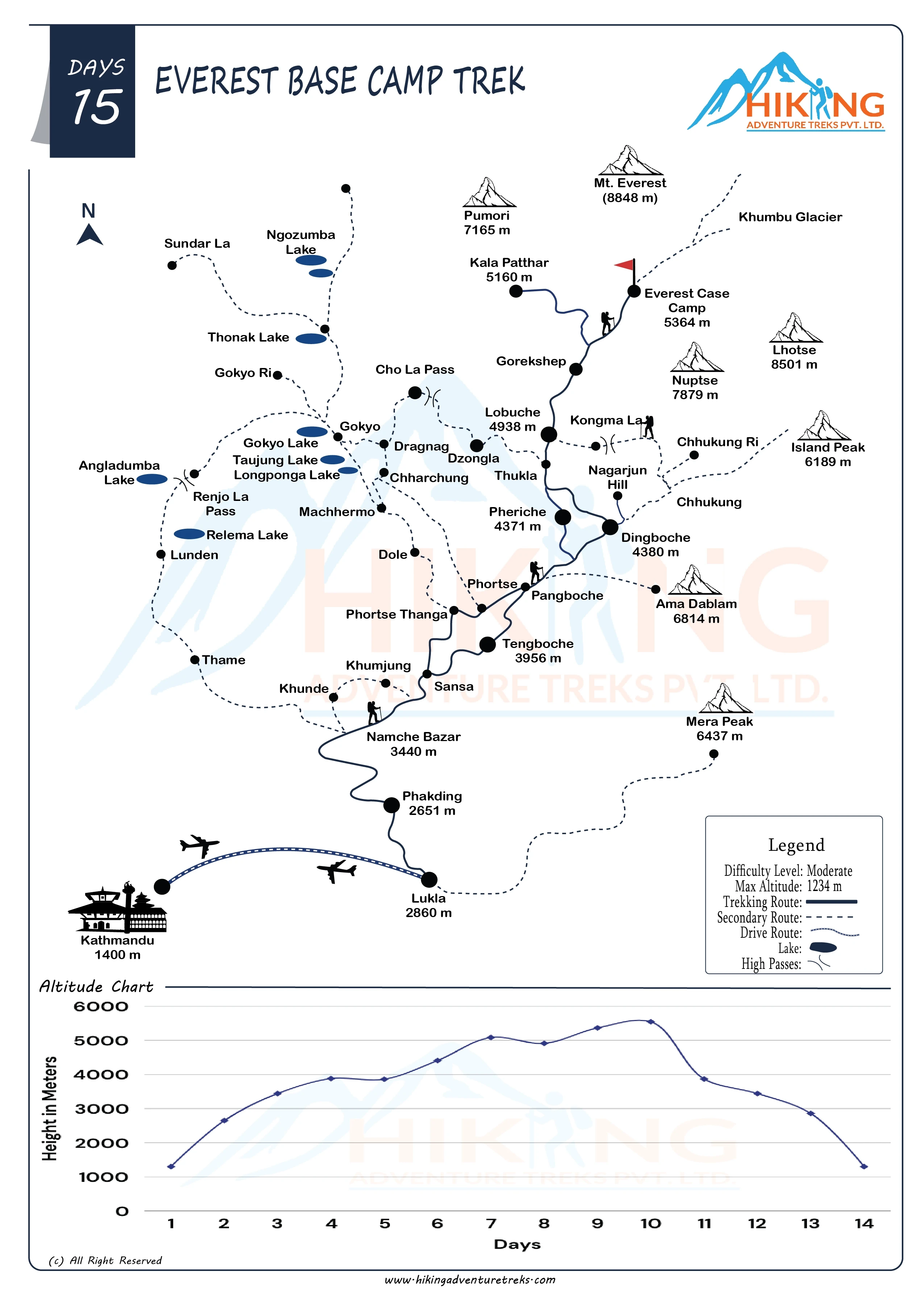
The journey to the base of the world's highest peak is a meticulously paced adventure, typically covering a total distance of 130 km (80 miles) round-trip. While the numbers on a map provide the framework, the actual experience is defined by a transition from lush river valleys to the stark, haunting beauty of the high alpine zone.
The Gateway: Lukla to Phakding
Your expedition begins with a thrilling, scenic mountain flight into Lukla (2,840m), the official gateway to the Everest region. This first day is designed to ease you into the environment, consisting of a gentle 8km (5-mile) downhill descent through the Dudh Koshi River valley. Over approximately three hours, you will wind through initial Sherpa settlements like Chheplung and Ghat before reaching Phakding (2,610m), a serene village nestled among lush forests and charming teahouses.
Phakding to Namche Bazaar
The second day introduces the first major challenge: a 10–12km trek involving a significant height gain of nearly 800 meters. You will follow the valley northward, crossing the Dudh Koshi River on thrilling suspension bridges and officially entering Sagarmatha National Park at the Monjo checkpoint. The journey culminates in a strenuous, steep zig-zagging climb that leads you into Namche Bazaar (3,440m), the bustling, crescent-shaped "Sherpa Capital" where you catch your first glimpses of Mt. Everest.
Namche to Tengboche
After a vital acclimatization day in Namche, the trail continues for 10–11km toward the spiritual center of the Khumbu. This stage offers some of the most spectacular vistas of the trek, including panoramic views of Ama Dablam, Lhotse, and Everest. After a steep descent to Phunke Tenga, you will face a steady uphill climb to reach Tengboche (3,860m). It is famously crowned by its ancient monastery set against a backdrop of jagged peaks.
Tengboche to Dingboche and Lobuche
As you move beyond Tengboche, the landscape transforms into the high-altitude alpine zone. The trek to Dingboche (4,410m) takes approximately five hours and is characterized by stone-walled fields constructed to protect crops from the harsh elements. From Dingboche, the path to Lobuche (4,910m) moves deep into the Khumbu valley. It involves a demanding climb up the terminal moraine to Thokla Pass, a somber and beautiful site featuring memorials for fallen climbers and Sherpas.
Lobuche to Gorakshep and Everest Base Camp
The final leg of the ascent is a 4–5km walk that runs parallel to the vast Khumbu Glacier. You will navigate rough, rocky moraine terrain for two to three hours to reach Gorakshep (5,140m), the last settlement with teahouses. From here, the ultimate goal is just a few hours away: a round-trip hike to Everest Base Camp (5,364m). Standing amidst the scattered tents on the gray glacier, you are surrounded by the Mahalangur Himal range, a moment that serves as a powerful symbol of your determination and willpower.
The Highest Vantage Point: Kala Patthar
Though Base Camp is the destination, many trekkers choose one final ascent to Kala Patthar (5,555m). This steep climb from Gorakshep rewards you with the ultimate panoramic view of Everest, where the sunrise paints the surrounding giants, including Pumo Ri and Nuptse, in hues of gold and pink. It is here, in the thinnest air of the journey, that you truly feel the magnitude of the Himalayas.
The Everest Base Camp Altitude Chart: Mastering Elevation
On the trek to Everest base camp , altitude is far more than just a number on a page; it is the primary force that shapes your entire experience. As you climb higher into the Himalayas, the air grows thinner, the temperature drops, and the demands on your cardiovascular system increase. The Everest Base Camp Altitude Chart serves as a visual testament to this vertical journey, revealing a narrative of gradual ascent and the unique challenges that each new elevation brings.
A Strategic Tool for Your Safety
The altitude chart is not merely a static piece of information; it is a strategic tool that empowers you to plan your journey with precision. By identifying high points and designated rest stops, the chart helps you align your physical efforts with the rugged terrain. This foresight is essential for optimal acclimatization, allowing your body the necessary time to adapt to decreasing oxygen levels and minimizing the risk of altitude-related issues.
Key Elevation Milestones
The chart highlights pivotal milestones where the air begins to change:
- The Starting Line: Your journey begins at Lukla (2,840m), where you may already feel the initial signs of altitude.
- The Acclimatization Hubs: Places like Namche Bazaar (3,440m) and Dingboche (4,410m) are vital "high-altitude havens." These aren't just rest stops; they are strategic points where you stay for multiple nights to "climb high and sleep low," often taking side trips to spots like the Everest View Hotel or Nagarjun Hill to prepare your lungs for what's next.
- The Thin Air Zone: As you pass Lobuche (4,910m) and reach Gorakshep (5,140m), the air becomes remarkably crisp, and the anticipation of reaching the base camp is palpable.
- The Summit View: The journey culminates at Kala Patthar (5,555m), the highest point on the trek, where the altitude reminds you that you are standing in rarefied air, surrounded by the magnitude of the world's highest peaks.
The Golden Rule: Listen to Your Body
One of the most precious pieces of "Khumbu guidance" you will ever receive is to ignore standard hour estimates for kilometers. Your map and altitude chart may tell you the distance, but they cannot tell you how your heart will beat in the thin air. The secret to mastering elevation is to walk slowly, listen to your body's warnings, and move with intention.
By understanding the implications of the altitude chart, you transform a daunting physical test into a calculated and confident adventure. It allows you to conquer not just the physical heights but also the emotional barriers of the trek, ensuring that when you finally stand at Everest Base Camp (5,364m), you do so with a sense of immense success and good health.
Exploring Alternative Map Routes
While the standard trail from Lukla is the most popular way to reach the foot of the world’s highest peak, the beauty of the Khumbu region is that it isn’t a single-track destination. Your trekking map actually reveals a web of interconnected trails, each offering a different flavor of adventure, from the quiet paths of the pioneers to the high-stakes drama of the alpine passes. Exploring these alternatives allows you to customize your journey based on your timeframe, fitness level, and thirst for solitude.
The Pioneers’ Path: Jiri to Lukla
Before the Tenzing-Hillary Airport was carved into the mountainside at Lukla, every legendary climber, including Sir Edmund Hillary, began their journey on the Classic Route from Jiri. This is the map for the "purist" who wants to earn every mile. Starting at an elevation of around 2,190 meters, this route cuts across the Ghaurishankar Conservation Area, leading you through lower-altitude valleys and charming villages like Bhandar and Ringmo. It adds several days to your journey but rewards you with incredible physical conditioning and a deeper immersion into the rural Nepalese way of life before you even join the main EBC trail.
The Scenic Masterpiece: Gokyo Lakes and Cho La Pass
If you want to escape the main trail's "trekking highway," look toward the western branch on your map. The Gokyo Lakes route is a fan favorite for those seeking a quieter, more diverse experience. This path diverges near Namche or Phortse and leads to the stunning, turquoise-blue glacial lakes of the Gokyo Valley. The highlight here is crossing the Cho La Pass (5,420m), a challenging high-altitude crossing that connects the Gokyo Valley back to the main trail toward Everest. It’s a route that offers a more panoramic, 360-degree perspective of the Himalayas, including views of Cho Oyu and the massive Ngazumpa Glacier.
The Ultimate Challenge: The Everest Three Passes Trek
For the most seasoned adventurers, the map outlines the Three High Passes Trek—the ultimate circuit of the Khumbu. This 18-to-19-day odyssey isn't for the faint of heart; it involves crossing the Renjo La, Cho La, and Kongma La passes, all of which sit above 5,000 meters. This route effectively circles the entire Everest region, offering the most comprehensive "map experience" possible. You’ll traverse remote valleys, high ridges, and glacial moraines that few other trekkers ever see.
Short on Time? The Helicopter Options
In recent years, the "Luxury" and "Heli-return" maps have become increasingly popular for those with limited schedules. These itineraries typically involve trekking one way to the Base Camp and then catching a helicopter flight back to Lukla or Kathmandu. It allows you to experience the grueling beauty of the ascent while skipping the repetitive descent, turning a 14-day journey into a 9-to-12-day highlight reel.
Whether you choose the classic approach or a high-altitude circuit, remember that these alternative routes are more than just different lines on a page—they are invitations to see a side of the Himalayas that most travelers never reach.
Digital vs. Physical Maps: Navigation in the Remote Himalayas
In the modern age of trekking, the debate isn't about whether to use technology, but how to balance it with traditional wisdom. Navigating the Khumbu requires a blend of high-tech convenience and low-tech reliability. While your smartphone can pinpoint your location within meters, the soul of the trail is often better captured on a folded sheet of paper.
The Digital Edge: Using Google Maps Offline
Can you use Google Maps on the way to Everest? The short answer is yes, but with major caveats. You can download the Everest region map for offline use while you still have strong Wi-Fi in Kathmandu or Lukla. Once you’re on the trail, your phone’s built-in GPS will track your movement as a "blue dot," helping you see your progress along the main route even without mobile data.
However, savvy trekkers often prefer specialized apps like Maps.me, Avenza, or Organic Maps. These alternatives provide much more detailed topographic data and offline trail coverage than standard Google Maps, making them far more reliable for hikers navigating high-altitude terrain.
The Physical Map: Your "Silent Advisor"
A physical, topographic map is more than just gear; it is an indispensable companion and a "silent advisor" that safeguards you against risks. It is a roadmap of lived experience that allows you to see every ridge, glacier, and river in one sweeping view.
There is a unique magic in "virtual travel"—moving your finger along the red-marked trails and tracing the contour lines before you ever take a step. It allows you to emotionally and physically prepare for the challenges ahead, helping you integrate with the environment rather than just following a digital line.
Pro-Tip: Where to Gear Up
Before heading to the mountains, visit the Thamel or Newroad districts in Kathmandu to buy a high-quality, laminated topographic map. You can find excellent selections at the Himalayan MapHouse near Basantapur for a reliable price, usually between NPR 380 and 600 ($3–$5 USD). Don't wait until you reach Lukla or Namche, as the price for the exact same map can nearly double once you're in the mountains.
Practical Information for Trekkers: Getting Your Hands on a Map
While the digital world offers convenience, the physical preparation for your trek is a ritual that often begins in the vibrant, bustling streets of Kathmandu. Finding the right map is like a mini-treasure hunt that sets the stage for the grand adventure ahead.
Where to Buy: The Best Map Hubs
For many trekkers, the journey truly starts in the labyrinthine streets of Thamel or Newroad in Kathmandu. These districts are the heartbeat of Nepal’s trekking culture, filled with shops offering everything from high-tech gear to ancient-looking scrolls. If you are looking for top-tier quality, head toward Basantapur (Kathmandu Durbar Square) and visit the Himalayan MapHouse. They are widely regarded for providing high-quality, often laminated maps that are durable enough to survive the moisture and wear-and-tear of a two-week expedition.
The Cost of Confidence
One of the best things about a physical EBC map is that it is an incredibly affordable insurance policy for your safety. Typically, you can expect to pay between NPR 380 and NPR 600 (roughly $3–$5 USD) for a detailed topographic map. The price varies slightly depending on whether you want a standard Lukla-to-EBC route map or a more comprehensive version that includes the classic Jiri approach or the Three Passes.
Timing Your Purchase: Kathmandu vs. The Trail
A piece of "insider wisdom" for the savvy traveler: buy your map before you fly to the mountains. While you can certainly find maps in Sherpa hubs like Lukla or Namche Bazaar, the cost of the exact same map often doubles once it has been transported into the Khumbu region. Furthermore, if you are booking through a local trekking agency, it is worth asking if a "tip map" is already included in your package, as many reputable companies provide these as part of their service.
A Final Logistics Note: The Gateway Shift
As you prepare to follow the first lines on your map starting at Lukla, be aware of a common modern logistical change: during peak trekking seasons, flights to Lukla are frequently diverted to Manthali Airport in Ramechhap. This means your physical journey may actually begin with a drive from Kathmandu to Ramechhap before you ever board the plane to the Tenzing-Hillary Airport. Knowing this ahead of time ensures that your transition from "map-reading" to "trail-walking" is as smooth as possible.
At Last,
As you fold your map for the final time and prepare to leave the Khumbu, you realize that the Everest Base Camp trek is an epic saga that transcends a mere physical test. What began as a series of dots and red lines on a piece of paper has transformed into a "roadmap of lived experience," where every contour now represents a memory of a ridge climbed, a glacier crossed, or a Sherpa village discovered. This journey is a transformative odyssey that allows you to integrate deeply with the environment, ensuring that you don't just follow a track but truly connect with the heartbeat of the Himalayas.
The map and altitude chart serve as your indispensable companions, unlocking secret attractions and cultural treasures like ancient Buddhist monasteries and sacred mani walls that you might have otherwise missed. Standing at the Base Camp at 5,364 meters, you aren't just looking at a destination; you are standing at a symbol of your willpower and a connection to a legendary climbing history. The thin air at the summit of Kala Patthar reminds you of the magnitude of nature, turning a daunting challenge into a moment of immense success and pride.
Ultimately, the map is a dynamic story of height, excitement, and the camaraderie shared with fellow hikers under star-scattered skies. It empowers you to conquer not only physical heights but also emotional barriers, proving that the journey itself is just as vital as the destination. You return home with more than just a souvenir; you carry a lifelong memory of the "Roof of the World" and the realization of a dream that will echo for a lifetime.